First, a few hours in Honolulu, just enough to realise how far Waikiki is from a dream island: concrete, steel and glass; shops, crowds and traffic jams.
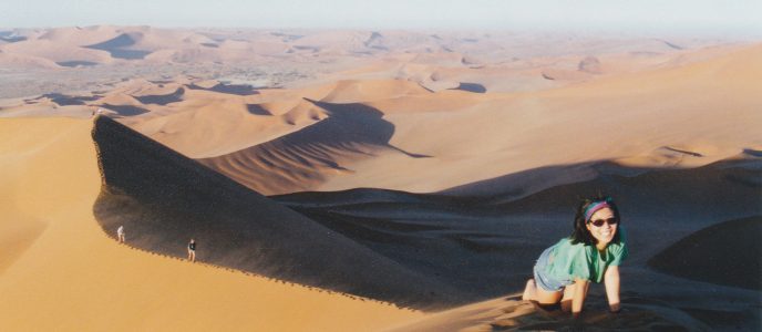
Then we flew to Kawaii to trek along the world famous NA PALI trail. This was our main reason to go there. Definitely the best trail anywhere! For days you walk along a trail winding up and down, suspended in between the ocean and steep cliffs. You shift within minutes from arid land to luxurious tropical jungle, from lava mountainous landscapes to sandy beaches. At any moment, from this trail, you can see herds of dolphins down the cristal clear seawater and, now and then, whales, sometimes alone, sometimes by two or three. Trekking there among fabulous flowers and trees is a permanent feast.
You’re not a trekker until you’ve done the Na Pali trail!
Next, we toured Big Island and enjoyed the VNP (Volcano National Park) and enjoyed its natural beauty: lava plains, lava craters, lava sculptures, lava plants and lava flows. We even went to the top of Mauna Kea to enjoy a lunar landscape.
Our first view in hawaii: Honolulu in WaikikiOur next view of Hawaii: Kawaii islandA coconut girl in a coconut grove?The start of the Na Pali trail in Kawaii island!On the road! Sorry, on the trail!A nice beach... for sea-weeds!Between ocean and cliffs, landscapes are breathtaking!A pictures hunterWatching flowersClimbing upAre you coming or not?Lost amid tropical plantsIt's quite difficult to find enough space to put a tent!The trail is never ending, but you never get bored with the views!Zoom outZoom inIf you still think it's a flat and hospitable island...Green and blue, that's it?How many colors do you get there?The trail has VANISHED!A mountain ridge diving into the oceanAt the end of the trail, a beach and a crowd: 5 people!A nice spot where to camp...Running water is a plenty!A cold shower at any time...A Hawaian sunset...
Our final leg was Big Island the well named, with its world famous Volcano National Park.
Our convertible four liter engine spoiling car for spoiled people...On top of Mauna Kea volcano, the highest mountain on earth: 12,000 m above the sea bed!Looks like on the moon, but for the blue sky. Don't you agree?Growing on Mauna Kea slopes is no fun!How could you look sunburnt on a black lava beach...Our base camp at the VNPA 2 km wide crater among many!Lava wrinkles, unless it is laces?Crossing a craterYou could cook a meal or anything, but certainly your soles!Anybody here? I feel I'm getting sucked in...At the sculpture museum!HELP! The earth is splitting apart!Too late...One more casualty: engulfed by the soft lava!It used to be a road...A war torn landscape!A few years later, a natural garden has appeared, without any man interferring!Trails are crisscrossing the VNPOn a rainy day!Birds are not afraid of manFlowers are quickly colonizing the new lava fields!The wonderful Tibouchina, ever present in Hawaii!
Created in 1963, the GR 10 is a French GR footpath, or hiking trail, that runs the length of the Pyrenees Mountains. It roughly parallels the French-Spanish border on the French side. The entire trail stretches from Hendaye on the Atlantic Ocean to Banyuls-sur-Mer on the Mediterranean Sea. (The Spanish GR 11 is a similar route on the Spanish side of the border, while the « Haute Randonnée Pyrénéenne » (HRP) follows a generally higher route through the Pyrenees, from mountaintop to mountaintop, frequently crossing the border).
Hiking the entire route is estimated to take around 2 months for hikers who are in good shape. The trail covers a distance of 866 kilometres, with 48,000 metres of ascent!
In June 2001, we hiked along the central part of the GR10, namely from Arrens to Bagnères de Luchon, with a complete week based in the Gavarnie mountain refuge from which we carried out day’s hiking into all directions.
Week 1
The first days were awful, it seemed we would never make it! Our training on the flat trails in the Paris area was definitely insufficient!
Priority is to the left…
Are you sure we have to climb this?
It’s so simple, just follow the trail!
Pavot de Californie
It’s not the top yet, still, we did a good job!
Ilheou mountain refuge, the welcome! Hi Suk is watching a « gypaete » (bearded vulture) by the glacier lake
Watching trouts…
At the foot of Vignemale the beautiful, a climber’s dream (or nightmare?). Its top reaches 3300 m.
Gentiane
A marmot following Hi Suk
Fed up with rain Today. It’s been a non stop rain since morning!
Pont d’Espagne, the ill-named as it is well located in France!
Above a sea of clouds
Rhododendron
Near the pass, it’s getting pretty cold!
Week 2
From the Gavarnie cirque mountain refuge, which became our base for a while, we hiked around for many days, enjoying fabulous landscapes and a gorgeous weather. We also entered Spain through the famous « breche de Roland ».
In « The Song of Roland »poem, Count Roland, Charlemagne’s nephew, attempts to destroy his sword « Durendal » to prevent it from being captured by the ambushing Saracens and creates « La Brèche de Roland » in the Pyrenees in the process. But Durendal proves indestructible, so he hurls it into a poisoned stream instead. Local folklore claims Durendal still exists, preserved in Rocamadour, France.
A half day trek to Gavarnie cirque, without a backpack, is just great!
On the way to Gavarnie cirque waterfall
The pyramidal « Pain de sucre » (sugar loaf), much bigger than Kheops!
I did it!
Crocus
On the way to « la breche de Roland »
Here’s the so famous « breche de Roland » ! A kind of door between Spain and France on the mountain ridge.
At this stage, no mountain can stop this splendid walking machine!
An eagle paparazzo!
The spanish side of the mountain range is much drier.
Apparently enjoying Spain…
Soldanelle des Carpates
Break time is always welcome!
Landscapes can be breathtaking!
Are you my friends or not? thinks the marmot
In June, you still face snow as soon as you get high enough
Looks like the silk road across Afghanistan!
Week 3
On the trail again, with difficult legs ahead ; when high altitude and bad weather combine, the trail addicts suffer!
At Mademate pass (2510 m), it’s freezing and bad weather is rushing on us…
On the way down to lac Aumar, the trail requires sometimes acrobatic skills!
The next day, after the snow storm, it was awfully difficult as there was no way the trail could be seen under the snow! After a while, we had to give up and walked along a closed road down to the nearest valley where snow was shallow. But that day was freezing cold and the worst ever. In the afternoon, we knew we couldn’t make the leg, so we gave up and ended up in a hotel to warm up!
Fortunately, the following day was glorious, and the landscapes outstanding…
…so we just walk around to enjoy weather and scenery, and recover from the previous day ordeal.
Week 4
The final week was quiter and more pastoral. In spite of the many difficulties and hardship, our legs were then made out of concrete so that nothing could slow us down. And on top of that, the many lakes dotting the landscapes were shining like jewels, attracting us further and further!
On the trail again, for longer but easier steps
Jean Claude parapenting
Ancolie
At Vielle-Aure, after a very long day…
Espingo lake and refuge chalet :so isolated but so rewarding! Once there, you just don’t want to leave…
At Espingo mountain refuge, in the sun, facing the lake, you enjoy the pleasure of the spirit, of the eyes and of the palate…
First, you think you have found paradise. But you’re wrong, by far! This place is so remote that everything has to be brought in or out by helicopter… So we stopped buying food!
Lys Martagon
J C’s riding a sand worm like a fremen on Dune planet (Dune by Frank Herbert)
Oo the well named! (specially when seen from above)
The view over Oo lake makes you forget how steep the trail is!
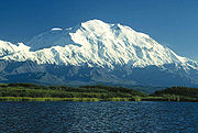
Alaska (mainland in inuit language) is by far the largest state of the USA. It is three times bigger than continental France. Alaska is one of two U.S. states not bordered by another state, Hawaii being the other. The state is bordered by the Yukon Territory and British Columbia, Canada, to the east, the Gulf of Alaska and the Pacific Ocean to the south, the Bering Sea, Bering Strait, and Chukchi Sea to the west and the Arctic Ocean to the north.
The best way to visit Alaska is to get on a trail. More than three quarters of Alaska is land locked up as parks, wildlife preserves and national forests. Alaska is also home of the highest peak in North America: Mt McKinley (6194 m).
We spent August 1999 hiking in two parks: Denali, to watch Mt McKinley, then Wrangell-St Elias.
1 – Arrival at Anchorage
Anchorage is blooming in August
First encounter of the bear type!
2 – Little Coal Creek Trail in Denali park
Denali park: Little coal creek trail
In Denali park, Little Coal Creek trail is a 30 mile trail famous for its breathtaking views of Mt McKinley. For days, we followed it through without getting a single glimpse of the mountain! It’s only when we boarded a car on the next day after the trek to leave the park that we saw Mt McKinley top out of the clouds!
Watching scores of red salmons (August is salmon run time)
My largest kitchen ever!
Picking up blue berries in my largest garden ever!
This bathroom offers only cold showers!
Hopping from lake to lake. I’m glad to know that Alaska includes about three million lakes, so I’m not done!
Skinny lake the well named!
Delicious blueberries will be again on the menu…
Opening a passageway through the boulders …
… and another one for climbers!
Some modestly call these boulders « Stonehenge »
Who said it’s an easy trail?
A painter’s dream!
You bet I’m tired!
Looks as big as Ayers Rock… but greener!
Did you see how BIG is my backpack?
A yellow living creature matching a yellow lichen background, some call it mimetism…
Are you sure we have to go on?
After four days of hiking along this trail, all we can do is pointing at Mt McKinley ghost, as it never showed up!
Is this ground squirrel (marmot) trying to console us?
This is for sure, these flowers are!
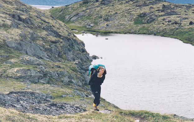
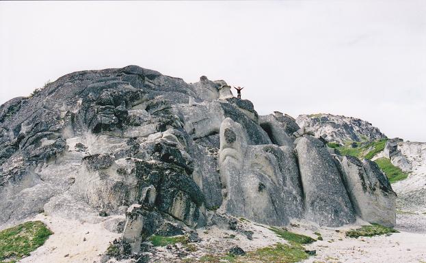
3 – Wrangell-St Elias National Park
Wrangell-St Elias Nat. Park sprawls across over 13 million acres in the south central region of Alaska. It abuts against Canada’s Kluane Nat. Park and together their 20 million acres represent one of the largest wilderness area left in the world.
The road to McCarthy, the main access to Wrangell-St Elias NP, begins with a highway sign informing you that the bridge at the end is washed out. Then it warns you to watch out for loose spikes. And finally it sends you off with this blessing: Drive at your own risk! At mile 60, the road abruptly stops. Over the Kennicott river, a footbridge leads you to McCarthy, a hamlet with a year-round population of 8 to 12 people, depending on who’s staying for the winter.
When we hitchhiked back to Anchorage, we met Malcom who drove us to McCarthy where he owned a cabin and a piece of land. This is where we had our base (on his land) for several weeks while we trekked for a few days at a time, along the Root glacier or the Bonanza mine for exemple (the world’s richest copper deposit ever found).
At McCarthy general store
At McCarthy country store
We shared a bottle of wine with Malcom
Along Root glacier
Along Root glacier
Walking and sliding on Root glacier
Breakfast by Root glacier
On this morning, before having breakfast, we had to wait until a black bear would clear the way so that we could retreive our food bag hidden (as every night) on top of a tree!
One of the bears we met along the trails…
The trail to Bonanza copper mine, with Kennicott and Root glaciers in the background
Above the tree line!
It looks like a volcano, but it’s only erosion!
Copper ore is everywhere…
On top of Bonanza peak!
A view from Bonanza peak
Near Glennallen airport, just before flying back to Anchorage and the civilization, I found my home!
The « Tour du Mont Blanc » is a ten to fifteen day trek around « Mont Blanc », Europe highest mountain.
Our trek lasted a full week. We did it clockwise, starting from « Le Tour » village just above Chamonix, and ending at « Notre Dame de la Gorge » close to « Les Contamines ». This represent about tree quarter of a full revolution, hence the duration.
After a week of intensive training, we joined a group lead by a guide… and a mule. To do it in a group limits your freedom, but has as main advantage to have a tent waiting for you every night and a mule to carry half your luggage. Our mule, Noisette (hazelnut in english) became soon our heroine when she proved so skilled and strong at climbing anywhere day after day. And withsole salary… grass and the carrots I had brought for her.
So we toured the Mont Blanc in July 2007. One of our most exhilarating experience!
Week 1 (training)
The pretty Le Tour village near Chamonix where we dropped our car and spent the first week.
Not quite near the top!
Lys martagon
Facing « les Aiguilles Rouges »
Nice encounter
Am I pretty?
Checking our location with GPS
Never high enough!
Facing les Aiguilles Vertes and Mont Blanc
At the top!
Over 2000 m high, it’s getting chilly
Azalea are still blooming in July
Shall we dash away or not?
Stilted water in lac Blanc
Week 2 (touring Mont Blanc)
Hi Suk, the guide and the mule Noisette. Who’s overloaded?
A crowd of trekkers crossing the swiss border
Ferret pass. We’re still fresh in the morning!
It seems it’s always climbing up!
La Peula, our only indoor bivouac. Hay can be a fabulous mattress!
Who said slit eyes?
Just follow the trail…
At Mt Dolent, the top of which belongs to France, Swizerland and Italy.
Beautiful gentian
Fabulous edelweiss
Great view at grand Ferret pass!
In the afternoon, tiredness is taking its toll!
Even climbing down is climbing!
A nice resting place near refuge Elisabetta
Lake Miage, another icy lake
The end of the day: tired but happy!
At Seigne pass
Fours pass: yes it is very steep!
Fours pass: ascending ahead of the group… and the mule!


")


, il fait très froid et le mauvais temps s'approche...")


")
")


 trying to console us?")


